Toronto to Vancouver: The Complete, No-Nonsense Guide to Getting Across Canada
Toronto to Vancouver isn’t just a line on a map. It’s a cross-Canada arc that jumps time zones, crosses the Canadian Shield, rolls through prairie skies, peers up at the Rockies, and drops into the Pacific. Whether you’re planning a quick flight, a bucket-list train ride, a road trip, or a full relocation, this guide gathers what you actually need to know—costs, routes, risks, timing, and smart ways to make the trip smoother.
Here you’ll find hard numbers, practical examples, Canadian-specific tips, and lived realities (like mountain passes in March, wildfire season in July, or figuring out a one-way rental without getting stung by fees). You’ll also see how to budget the drive, how VIA Rail really works, what airlines and airports are like today, and what to do if you’re moving your life—furniture, car, cat and all—from Toronto to Vancouver.
Quick Answers: Distance, Time, and Best Ways to Travel
Let’s get the essentials out quickly before diving deep. The “right” way to go from Toronto to Vancouver depends on your priorities—time, money, scenery, comfort, or flexibility. This table sets the stage.
| Mode | Typical Time | Ballpark Cost (1 adult) | Best For | Need-to-Know |
|---|---|---|---|---|
| Flight (nonstop) | ~5 hours in the air (add airport time) | $150–$800+ round trip (season-dependent) | Speed and convenience | Watch baggage/seat fees; nonstop options daily; 3-hour time change |
| Train (VIA Rail “The Canadian”) | ~4 days/4 nights | Economy ~$400–$1,000; Sleeper $1,500–$5,000+; Prestige higher | Scenery and slow travel | Freight has track priority; delays happen; book early for sleepers |
| Bus (intercity carriers) | ~60–70 hours with transfers | $250–$500+ | Lowest out-of-pocket cost | Limited schedules; basic comfort; plan transfers carefully |
| Drive (car/RV) | ~4,400 km; 40–45 hours wheel time | $700–$1,500+ fuel/tolls; plus hotels, food, wear | Flexibility, sightseeing, moving | Winter tires in BC (signed routes); mountain passes; wildfire season |
By air, it’s about 3,350 km (great-circle) and roughly five hours in the sky. By road, it’s closer to 4,300–4,500 km depending on your route, and you’ll pass through Ontario, Manitoba, Saskatchewan, Alberta, and British Columbia. You’ll cross from Eastern Time to Pacific Time, so Vancouver clocks read three hours earlier than Toronto’s.
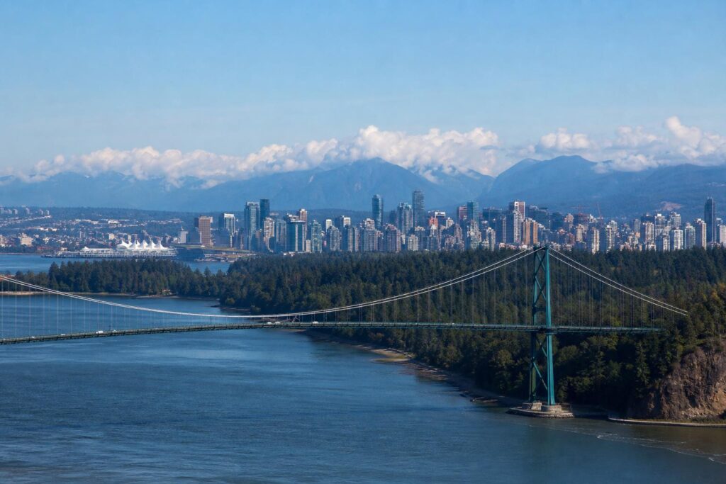
Flying Toronto to Vancouver: Fast, Frequent, and Usually the Easiest
Most Canadians fly this route; it makes sense if you’re short on time or if winter conditions make a drive unappealing. The Toronto (YYZ) to Vancouver (YVR) corridor is one of the busiest in the country, so you’ll find multiple nonstop flights every day and even more one-stops if your schedule is flexible.
How Long Is the Flight from Toronto to Vancouver?
Nonstop flight time sits around five hours westbound and often a bit less eastbound due to prevailing winds. Realistically, block out 8–9 hours door-to-door including getting to Pearson, security, boarding, taxi time, deplaning, and the Canada Line into downtown Vancouver.
Pro tip: The time change works in your favour westbound. A late-morning departure from Toronto often lands early afternoon in Vancouver, so you can still enjoy part of the day. Coming back east can feel longer, especially on red-eyes.
Airlines, Airports, and What’s New
Major carriers on the Toronto to Vancouver route typically include Air Canada and WestJet, with additional competition from Flair Airlines and, increasingly, Porter Airlines on jet equipment. Low-cost options advertise cheap base fares but charge for almost everything else. Swoop merged into WestJet, and Lynx Air ceased operations in 2024, so you’ll see fewer ultra-low-cost players than a few years ago.
At Toronto Pearson (YYZ), Air Canada mainly uses Terminal 1; WestJet and Flair typically use Terminal 3. Porter’s longer-haul jets run from Pearson rather than Billy Bishop for this route. Vancouver International (YVR) is efficient, with easy connections to downtown via the Canada Line (roughly 25 minutes). In Toronto, the UP Express links Pearson and Union Station in about the same time. Both trains run frequently and are the simplest option during rush hour.
What Does It Cost to Fly Toronto to Vancouver?
Airfare swings by season, competition, and how early you book. Typical round-trip economy:
- Off-peak (late fall, winter shoulder, early spring): $150–$350 if you watch sales
- Peak summer and holidays: $350–$800+ is common, sometimes more last-minute
- One-way tickets can be good value when mixed across carriers using tools like Google Flights
Fees add up. Expect seat selection charges on many fares, and checked baggage is often $30–$40+ each way on full-service airlines in basic economy, while low-cost carriers charge for carry-on, checked bags, and sometimes printing a boarding pass at the airport. If you’re flying with sports gear or instruments, look up special-item rules in advance to avoid painful gate surprises.
Point Collectors: This Route Is Your Playground
For Aeroplan collectors, YYZ–YVR is a bread-and-butter redemption route, especially if you catch a low “dynamic” price on off-peak dates. WestJet Rewards holders can offset costs with WestJet dollars. Many Canadian premium cards offer an annual companion fare or flight credit that shines on cross-country trips. Keep an eye on your card’s included insurance; many cover trip delay, baggage delay, and basic travel medical within Canada.
Airport Tips That Actually Help
- Security lines: Toronto Pearson varies. Check CATSA’s online wait-times and arrive earlier during school breaks. NEXUS speeds things up considerably.
- Winter operations: De-icing is routine in YYZ. Build buffer time if you have same-day connections.
- Food and water: Fill a bottle after security. On many domestic fares, food is buy-on-board; snacks are your friend.
- Seating comfort: If you’re tall, check aircraft type. A Boeing 787 or Airbus A330 (if scheduled) beats a denser single-aisle for legroom, though widebodies aren’t guaranteed on this domestic route.
Toronto to Vancouver by Train: Slow Travel with Big Views
VIA Rail’s “The Canadian” links Toronto’s Union Station and Vancouver’s Pacific Central Station. It’s not about getting there quickly; it’s about seeing the country glide by, from lakes and forests to open prairie and into serious mountains. If you’ve been meaning to unplug and let someone else do the driving, this is it.
Schedules, Timing, and Why Delays Are Normal
The journey is roughly four days and four nights. It’s a long-haul run on freight-owned tracks, and freight trains have priority. That means arrival and departure times can drift. Bring patience and build a buffer day at the end if you’ve got a connection or event in Vancouver. Think of the schedule as best case, not a guarantee.
Seasonal adjustments exist; during peak periods VIA often adds staff and onboard programming. Seats and sleepers open for sale many months in advance, and popular dates sell out early—particularly cabins with showers and the Prestige class.
Economy vs. Sleeper vs. Prestige
Economy gives you a reclining seat, shared washrooms, and access to basic food options to purchase. It’s the cheapest way to ride, but it’s a long four nights if you don’t sleep well in seats. Sleeper Plus gets you a berth or cabin, meals, shower access, and lounge perks at some stations. Prestige is a luxury cabin with a private shower, big window, concierge service, and a price tag to match.
Ballpark fares (very approximate, and vary widely by date and demand):
- Economy: ~$400–$1,000 one way
- Sleeper Plus (berth/cabin for one): ~$1,500–$5,000+ per person
- Prestige: significantly higher, often five figures on peak dates
Tip: If your heart is set on a sleeper but you’re cost-conscious, look for shoulder season departures and book as early as possible. VIA runs promotions occasionally—newsletter sign-ups help.
What It’s Like Onboard
You’ll spend time in dome and viewing cars, chat with travellers, and watch the landscape change at human speed. The food in Sleeper Plus is solid, and the crew knows the route. The Wi‑Fi situation is limited; download what you need beforehand and plan to be offline in rural stretches. Bring a power bank, eye mask, and layers—cars can feel chilly at night. If you’re an avid photographer, a polarizing filter helps with glass reflections.
Bus from Toronto to Vancouver: The Frugal Long Haul
Intercity bus service across Canada changed after Greyhound Canada shut down. Today, service exists, but it’s patchwork with fewer frequencies. Carriers like Rider Express have aligned east–west corridors with transfers in major hubs. Expect a multi-day run with simple amenities, tight layovers in some places, and a very budget-friendly fare compared with flying last-minute or booking a sleeper on the train.
Reality check: Seats are fine for a day; two or three nights in a row is tough. If you can break the trip with an overnight in Winnipeg or Calgary, you’ll feel human again. Book directly with the carrier so schedule changes reach you, and confirm how luggage works—allowances and fees vary and can be stricter than you expect.
Driving from Toronto to Vancouver: Routes, Real Distances, and Smart Timing
If you want control of your schedule or you’re relocating with a car or pets, driving Toronto to Vancouver makes sense. It’s a classic Canadian road trip—manageable with planning and a few ground rules.
How Far and How Long?
The drive is roughly 4,300–4,500 km depending on route. Wheel time is around 40–45 hours if you moved like a long-haul trucker. Most people need 5–8 days to do it safely and enjoyably, more if you’re sightseeing in national parks.
A simple way to think about it: aim for 500–800 km per day depending on conditions, daylight, and your appetite for driving. In summer with long evenings you can push farther. In winter, shorter days and tougher roads argue for conservative legs.
The Three Main Route Styles
1) The Classic Trans‑Canada (Highway 17/1)
This is the default route on most GPS apps. You’ll leave Toronto on Highway 400 or 401, join Highway 17 north of the Great Lakes, then connect to Highway 1 through the Prairies and Rockies. It’s direct, beautiful through Lake Superior and the Rockies, and well-served for fuel and lodging.
Highlights include the Lake Superior coastline near Sault Ste. Marie and Thunder Bay, prairie big-sky sunsets, Banff and Yoho national parks, Rogers Pass, and the Fraser Valley into Vancouver. In winter, be ready for snow from Northern Ontario right through to the mountains; in summer, look out for construction zones and wildlife at dawn and dusk.
2) The Yellowhead Option (Highway 11/16 via Jasper)
Cutting northwest to the Yellowhead Highway (Hwy 11/16) takes you through Thunder Bay, then across the Prairies to Saskatoon and Edmonton, before dropping into Jasper, Mount Robson, and the North Thompson River valley to Kamloops. Scenery is massive, traffic often lighter than the main Trans‑Canada, and the Jasper area is unforgettable. If Vancouver Island or the Sea-to-Sky is on your mind, the Yellowhead puts you in a good spot to branch off via Whistler after reaching the Lower Mainland.
3) The Dip Through the U.S. (If You’re Eligible and It Suits You)
Some travellers route through Michigan, Wisconsin, North Dakota, Montana, Idaho, and Washington before re-entering at the Pacific. Why? Sometimes weather, sometimes faster interstates, sometimes lower fuel prices. But this adds border requirements: Canadians need a valid passport to enter the U.S., and cannabis that’s legal in Canada is strictly illegal at the border. Rental cars need explicit cross-border permission, and you should confirm your insurance covers U.S. driving. If you’re not keen on border logistics, keep it all-Canada.
Mountain Passes and BC-Specific Rules
British Columbia requires winter tires (look for the mountain-snowflake or M+S marking) on certain signed highways from fall to spring—commonly October 1 to April 30 on routes like the Coquihalla (Highway 5) and the Okanagan Connector (Highway 97C). Enforcement varies by conditions and signage, but it’s your responsibility to be compliant when you see those signs. Even outside those dates, early snow can surprise you at elevation. Commercial vehicles have chain requirements. For passenger cars, proper winter tires are strongly recommended anywhere snow is likely.
Key passes you might encounter include Rogers Pass (Glacier National Park), the Kicking Horse Pass area near Field/Golden, and if you choose Highway 5, the Coquihalla. All can get serious weather, and all are well-maintained by Canadian standards. Check DriveBC before committing to a mountain leg.
Trusted Road and Condition Resources
- Ontario 511 for Hwy 17 and construction zones
- Manitoba 511 and Saskatchewan Highway Hotline
- Alberta 511 for Bow Valley, Canmore, Banff, and Highway 1 updates
- DriveBC for mountain passes, avalanche control, and incidents
- Parks Canada for national park road advisories and passes
One-Way Car Rentals: Fees, Loopholes, and Alternatives
One-way rentals from Toronto to Vancouver are common, but not cheap. Drop fees are often in the $500–$1,500+ range, and can spike in summer. Look at:
- Relocation deals: Some companies discount “drive-away” cars that must reach the West Coast. Inventory changes quickly.
- Membership codes: Corporate, alumni, or association codes can blunt fees. Ensure you qualify.
- Different pickup points: Pearson vs. downtown or suburban depots sometimes alters pricing by hundreds of dollars.
Check cross-border clauses carefully—even if you don’t plan to use the U.S. route. If you do cross into the U.S., you’ll need written permission on your contract, and returning to Canada at a different border point than planned can complicate things if the agreement was restrictive. Fuel policy, kilometres included, and additional driver fees matter on a trip this long.
The Cost of Driving Toronto to Vancouver: A Realistic Budget
Everyone asks: How much does the drive cost? It depends on your vehicle, sleep style, and how many people split the bill. Here’s a framework you can adapt in five minutes.
Fuel Math You Can Trust
Pick three numbers: total distance (say 4,400 km), your car’s consumption (example: 8.5 L/100 km), and an average fuel price (substitute your local number). Multiply it out:
- Fuel needed ≈ 4,400 km × 0.085 = 374 litres
- At $1.80/L: 374 × $1.80 ≈ $673
If your SUV averages 11 L/100 km and gas is pricier, the number climbs; if you drive a hybrid at 5 L/100 km, it drops a lot. Tweak the inputs and you’ll get a personalized estimate in seconds.
Hotels, Food, and Tolls
- Hotels/motels: $120–$200+ per night outside the Rockies; $200–$350+ in Banff/Jasper peak season. Booking ahead in summer is wise.
- Food: Groceries and a cooler save money. Assuming $20–$35 per person per day if you mix supermarket meals and one restaurant.
- Tolls: The Trans‑Canada itself is toll-free, but Highway 407 ETR in the GTA is tolled by time/distance and can add up quickly. You can avoid it with Highway 401/400 if you’re not in a rush.
- Park passes: Banff, Yoho, Glacier, and Mount Revelstoke all require a Parks Canada pass for stopping/parking, not just passing through.
Sample Budgets
| Item | Frugal (solo, 6 nights) | Comfort (2 people, 7 nights) |
|---|---|---|
| Fuel (example 8.5 L/100 km at $1.80/L) | $675 | $675 |
| Accommodation | $120 × 6 = $720 | $180 × 7 = $1,260 |
| Food | $25/day × 7 ≈ $175 | $50/day × 8 × 2 ≈ $800 |
| Park passes/tolls/misc. | $80 | $200 |
| Total (approx.) | $1,650 | $2,935 |
Two people in one car dramatically cut per-person transport costs. Solo drivers can still keep it reasonable by choosing motels off the main tourist strips and packing meals.
When to Drive: Seasons, Wildfire Reality, and Winter Truths
Timing changes everything on a Toronto to Vancouver road trip. You can make the drive in any season with the right preparation, but the experience shifts with daylight, weather, and crowds.
May to September: Long Days, Construction, and Peak Prices
Late spring to early fall is road-trip season. Northern Ontario’s bugs can be assertive in June, but the light is glorious and lakes are warm enough for a swim by July. In the Rockies, July and August are high season—beautiful, busy, and expensive. If you want Banff/Lake Louise parking at a decent hour, set an alarm. September is a sweet spot: kids back in school, larches turning gold near higher elevations, and (often) stable weather.
Wildfires have become a steady-season concern across Western Canada. Smoke can reduce visibility for days and prompt travel advisories or closures. Check provincial wildfire dashboards and DriveBC updates, and book accommodations with flexible cancellation where possible. Pack N95 masks if smoke triggers you.
October to April: Snow Tires, Shorter Days, and Big Sky Drama
Winter drives ask for respect. Snow and ice through Northern Ontario and the Rockies require proper tires, extra stopping distance, and a calm approach. BC’s signed winter tire requirement applies to many inland routes from October 1 to April 30, and it’s not just a suggestion. Watch for black ice near bridges, blowing snow on the Prairies, and sudden squalls along Lake Superior.
That said, a clear winter day across the Prairies is gorgeous, and hotel prices are friendlier. Keep an eye on wind warnings; semis and high-profile vehicles can struggle in gusts. If a storm is ripping across the map, sit tight, have a hot drink, and head out once plows have worked their magic.
Stops Worth the Miles: Building a Toronto to Vancouver Itinerary
You can sprint the distance or turn it into a greatest-hits album. Here are popular stops and how they fit different timelines.
Fast But Sane (5–6 Days)
- Day 1: Toronto to Sault Ste. Marie (or Wawa for a push)
- Day 2: To Thunder Bay (Kakabeka Falls detour if time)
- Day 3: To Winnipeg (city dinner; overnight downtown or near the Perimeter)
- Day 4: To Regina or Moose Jaw (short soak at Temple Gardens if you need it)
- Day 5: To Calgary (or Canmore to set up Banff)
- Day 6: Through Banff/Yoho/Rogers Pass to Kamloops, then on to Vancouver
Scenic and Balanced (7–10 Days)
- Lake Superior Coast: Sault Ste. Marie to Terrace Bay/Marathon—it’s endlessly photogenic
- Winnipeg: The Forks and the Canadian Museum for Human Rights
- Grasslands/Prairie: Detour to Moose Jaw tunnels or Saskatoon’s river valley
- Alberta Rockies: Two nights split across Banff and Jasper for hikes and viewpoints
- BC Interior: Okanagan wine or the Fraser Canyon; then Vancouver’s seawall to stretch out the legs
Don’t try to “do it all” in Banff in one afternoon. If you only have a few hours, choose a core experience: Lake Louise at dawn, Johnston Canyon walk, or the Banff Gondola and a short hike. Traffic and parking shape the day in summer; arrive early or ride shuttles when offered.
Safety, Laws, and Canadian Realities You Shouldn’t Skip
Most of this trip is straightforward, but a few regulations and norms deserve your attention. They’re not red tape; they’re practical protections for you and everyone else on the road.
Speed Limits and Enforcement
Typical rural limits: 100 km/h in Ontario and the Prairies, with posted 110 km/h on some upgraded sections, and up to 120 km/h on certain BC highways. Enforcement varies—provincial police and the RCMP patrol highways, and photo enforcement may appear in construction zones or municipalities. Fines escalate quickly with speed, and in some provinces excessive speed can trigger vehicle impoundment. It’s not worth the risk.
Insurance and Proof of Coverage
Carry proof of insurance and registration. Many provinces now accept digital insurance slips; check your provider’s policy and keep a paper copy as a backup. Out-of-province drivers are covered in other provinces, but know your deductibles and limits. If you’re renting, photograph the car at pickup and drop-off, including the roof and windshield.
Alcohol, Cannabis, and the Border
Alcohol and cannabis laws are provincial. Legal purchase ages differ (generally 18 or 19), and public consumption rules vary. None of that changes impaired driving laws—Canada has strict Criminal Code offences for both alcohol and drug impairment, with roadside testing and administrative penalties. If you’re dipping into the U.S. at any point: do not carry cannabis across the border, period.
Wildlife and Night Driving
Moose, deer, elk, and black bears don’t care about your ETA. Dusk and dawn are the riskiest. If you see a moose sign, believe it—hitting one can be catastrophic. Slow down in signed zones, scan shoulders, and avoid long night runs in high-risk stretches, especially in Northern Ontario and between Golden and Revelstoke.
Electric Vehicles on the Toronto to Vancouver Route
Driving an EV cross‑country in Canada is absolutely doable now with a little planning. The backbone includes Petro‑Canada’s Electric Highway, Tesla Superchargers (some now open to non‑Tesla vehicles with CCS/NACS compatibility), and regional networks like Electrify Canada. The Prairies and mountain corridors have DC fast chargers spaced reasonably, though redundancy is thinner than in Southern Ontario and the Lower Mainland.
Practical EV Tips
- Plan with PlugShare and A Better Routeplanner, and have at least two network apps/cards set up.
- In winter, expect reduced range and slower charging at very low temperatures—add buffer.
- Book accommodations with Level 2 charging; topping up overnight simplifies the day.
- Arrive at fast chargers with 10–20% for quicker charging curves when possible.
If you’re renting, Canada is catching up on EV availability, but one-way EV rentals remain limited and pricier. Confirm included adapters and network memberships before pickup.
Moving from Toronto to Vancouver: Shipping, Housing, and Settling In
Relocating across the country is its own project. It’s not just the drive—you’re balancing movers, housing, employment timing, schools, and a three-hour time change. The more you front-load planning, the smoother your landing.
How to Move Your Stuff
- Portable containers (PODS, BigSteelBox, and similar): You pack; they ship. Mid-range cost and flexible timing. Delivery windows in Vancouver can be tight in denser neighbourhoods, so check local bylaws/permits for street placement.
- Full-service movers: They pack, load, and deliver. Easiest, priciest. Read reviews, confirm insurance, and get a binding or not-to-exceed quote in writing.
- DIY truck (U‑Haul, Penske, etc.): Cheapest cash outlay, most labour. Factor fuel, hotel nights, and your energy level after a 4,400 km drive in a box truck.
Very rough cost ranges for a 1–2 bedroom move can swing from a few thousand dollars with a container to five figures for premium full-service movers. Transit times are commonly 7–14 days door-to-door, longer at peak season. If you’re renting in Vancouver, time your move for the 1st/15th waves and secure elevator bookings well in advance—strata rules can be strict.
Shipping a Car
Most Canadians either drive the car themselves or hire an auto transport carrier. Open transport is cheaper; enclosed is pricier and usually unnecessary unless the vehicle is high-value. Expect a week or two in transit and make sure the company provides proper insurance documentation. There isn’t a consumer-facing “auto train” service in Canada like Amtrak’s Auto Train in the U.S.
Housing and Cost-of-Living Notes
Toronto and Vancouver sit at the top end of Canadian housing costs. Market conditions shift, but you can expect high rents and competitive openings in central areas of both cities. The safest way to compare current numbers is to check the latest CMHC Rental Market Reports and combine them with real-time listing platforms. Be mindful of scams; never wire money for a place you haven’t seen, and confirm ownership or property management details before transferring deposits.
Utilities differ. In Vancouver, many apartments include heat and hot water if they’re boiler-based, while electric baseboard units can mean higher winter bills. In Toronto condos, hydro is often metered separately. Budget for transit passes if you won’t have a car; both cities have strong transit networks, and Vancouver’s SkyTrain and frequent buses mean you can live car-free in many neighbourhoods.
Work and Time Zones
If you’re keeping Toronto hours while living in Vancouver (common for remote workers), the three-hour gap shifts your day earlier. Many people start at 6:00 a.m. Pacific and finish mid-afternoon, which can be great for lifestyle if you’re morning-oriented. On the flip side, late Toronto meetings can collide with Vancouver dinner. Agree on core hours with your team.
Inside the Numbers: Toronto to Vancouver Distance and Time Conversions
For quick planning and search clarity, here are simple reference figures you can rely on:
- Toronto to Vancouver distance by air: roughly 3,350 km
- Toronto to Vancouver flight time: about 5 hours nonstop (plus airport time)
- Toronto to Vancouver distance by car: roughly 4,300–4,500 km depending on route
- Toronto to Vancouver driving time: 40–45 hours of wheels-turning, not counting stops
- Time zones: Eastern Time (Toronto) to Pacific Time (Vancouver) = 3 hours earlier in Vancouver
Money-Saving Tactics Specific to This Trip
You don’t need to get extreme. A handful of smart moves pay out across a cross-country journey.
- Fly smart: Use Google Flights to watch price drops, then book direct with the airline. Midweek departures often price lower; early booking helps for peak summer.
- Mix and match: One-way fares on different carriers can beat round trips. Red-eyes west-to-east can be cheaper.
- Drive cheaply: Share a car. Two drivers cut hotel and fuel cost per person by half and let you cover more ground safely.
- Stock the cooler: Even one grocery run per day cuts costs and time vs. detouring for restaurants.
- Avoid 407 ETR unless it truly saves you: The time gain may not justify the tolls if you’re not racing the clock.
- National parks: If you’re spending multiple days in Banff/Jasper/Yoho, a Discovery Pass can be cost-effective vs. daily passes.
Toronto to Vancouver by Car: Packing and Prep That Pay Off
You don’t need an expedition checklist, but a few items punch above their weight on this route.
- Winter kit (year-round in the trunk): blanket, gloves, water, snacks, scraper, reflective triangle, booster cables, phone power bank
- Paper maps: Cell coverage is broad but not universal, especially in Northern Ontario and mountainous BC
- Spare key strategy: Don’t lock your only fob in the trunk 2,000 km from home
- Headlamp and microfiber towel: For surprise fixes and rainy luggage runs
- Bear sense: In parks, store food properly and keep your distance; a telephoto lens is not optional for wildlife shots
Before leaving, check your tires (including the spare), brakes, wipers, and all fluids. If your battery is older and you’re heading into winter, consider replacing it pre-emptively. A small OBD-II scanner can save a lot of mystery if a dash light pops up.
Air vs. Train vs. Bus vs. Car: Which Toronto to Vancouver Option Fits You?
Still undecided? Frame it this way:
- Choose flight if time is tight and you want minimal logistics.
- Choose train if the journey itself is the goal and your schedule can flex.
- Choose bus if budget trumps comfort and you’re fine with transfers.
- Choose car if you want flexibility, sightseeing, or you’re moving stuff.
Blended options exist too. Fly to Calgary, rent a car for the Rockies and BC, then drop in Vancouver. Or take VIA Rail to Jasper, rent a car there, and continue west by road. You can even fly Toronto to Vancouver and ride the train back, catching both perspectives.
Toronto to Vancouver with Kids or Pets
Families can absolutely do this trip without misery. For flights, book seats together early—don’t rely on gate swaps. Pack a small kit of snacks, wipes, and a surprise activity for the last hour when patience runs thin. Vancouver’s Canada Line is stroller-friendly, as is the UP Express in Toronto.
Driving with kids? Rotate the front-seat adult every few hours, run the big-energy stop at a real park (not a gas station), and front-load audiobooks or podcasts before leaving. With pets, plan pet-friendly motels in advance and build in longer stops. Never leave an animal in a hot car, especially in the Prairies and BC interior during heat waves.
Accessibility Considerations
Airports in Toronto and Vancouver have robust accessibility services—arrange assistance with your airline at booking or after purchase. VIA Rail offers accessible cabins on “The Canadian,” but inventory is limited and must be reserved early. On a road trip, verify motel room accessibility directly with the property; standards vary, and a “ground floor” listing isn’t the same as a roll-in shower.
What About Working or Studying on the Move?
Domestic Canadian mobile plans generally include Canada-wide calling and data, but some value plans throttle or treat coverage outside your provider’s core network differently. Confirm details with your carrier, especially if you’re on a regional plan. For laptops, pair your phone’s hotspot and cache what you need for offline stretches—Northern Ontario and mountain valleys can still feel 1999 for coverage.
Environmental Footprint: Practical Steps Without Preaching
Flying has the highest per-person emissions; driving solo in a large SUV isn’t far behind. Easiest wins: share a car, keep speed moderate, and avoid roof boxes if you can (they crush efficiency). If you love the idea of seeing the country slowly, the train shares footprint across many riders and keeps you off highways entirely. If carbon offsets matter to you, choose verified projects and consider pairing offsets with a concrete behaviour change like a rideshare leg or skipping one hotel night’s worth of energy use by staying with friends or family en route.
Sample Seven-Day Toronto to Vancouver Road Trip Itinerary
Use this as a starting point and adjust to your interests and season.
- Toronto → Sault Ste. Marie (690 km): Late start friendly; waterfront walk, early night.
- Sault Ste. Marie → Thunder Bay (700 km): Lake Superior’s finest. Stop at Old Woman Bay and Terrace Bay viewpoints.
- Thunder Bay → Winnipeg (700 km): Kakabeka Falls breakfast stop. Easy prairies arrival; dinner at The Forks.
- Winnipeg → Moose Jaw/Regina (650–575 km): Flat, fast, and often windy. Soak or stroll downtown.
- Regina → Calgary (760 km): Big sky day; detour to Drumheller if energy allows.
- Calgary → Golden/Revelstoke (260–410 km): Banff/Yoho core—choose hikes wisely; traffic dictates pace.
- Golden/Revelstoke → Vancouver (620–560 km): Rogers Pass drama, fuel at Sicamous/Salmon Arm/Kamloops, then Fraser Valley home stretch.
Troubleshooting the Trip: Common Snags and How to Avoid Them
- “We hit construction everywhere.” It’s summer in Canada. Leave earlier, accept minor detours, and plan a non-negotiable stretch stop so delays don’t compound grumpiness.
- “The one-way rental fee is brutal.” Price multiple companies, pick odd pickup/return locations, or watch relocation boards. Sometimes shifting the date by a day drops the fee by hundreds.
- “The train was late.” That happens. Build a buffer day after arrival if you have onward plans, and bring a mindset for slow travel.
- “Wildfire smoke wrecked the views.” It’s part of the new normal. Check conditions, carry masks if you’re sensitive, and be ready to reroute or add a day until air quality improves.
- “We were exhausted by Day 3.” Cut your daily distance, add a real rest stop, and swap drivers more often. No schedule is worth risky driving.
Toronto to Vancouver: Final Take
There isn’t one “best” way across the country. There’s the way that matches your calendar, budget, and appetite for adventure. If you want speed, fly. If you want stories, take the train. If you want control and flexibility, drive. And if your wallet sets the rules, the bus might carry the day. However you go, check conditions, keep your expectations grounded, and give yourself space to enjoy the shift from lake country to mountains to the ocean. That sweep is why the Toronto to Vancouver journey sticks with people for years.
FAQ: Toronto to Vancouver
How long is the flight from Toronto to Vancouver?
About five hours nonstop in the air, plus airport time on each end. Door-to-door, plan for 8–9 hours.
What’s the distance from Toronto to Vancouver by car?
Roughly 4,300–4,500 km depending on the route you choose. Expect 40–45 hours of actual driving.
Is it safe to drive Toronto to Vancouver in winter?
Yes, with preparation. Equip proper winter tires (required on many BC highways during signed dates), watch forecasts, carry an emergency kit, and don’t push in storms. Use provincial 511 sites and DriveBC to time mountain passes.
What’s the cheapest way to travel from Toronto to Vancouver?
Usually the bus for strictly the lowest fare, followed by ultra-low-cost flights on sale. If two or more people share a car and stay in budget motels with grocery meals, the road trip can be competitive on a per-person basis.
How much does it cost to drive from Toronto to Vancouver?
Fuel alone for a typical sedan might land in the $600–$800 range depending on consumption and gas prices. Add $700–$1,500 for hotels/food/fees over a week. Two people sharing a car cut the cost per person substantially.
Which route is most scenic?
The Trans‑Canada past Lake Superior and the Rockies is the classic. The Yellowhead via Jasper offers equally grand scenery with a slightly different flavour and often lighter traffic.
Do I need a passport to drive through the U.S. on the way?
Yes. Canadians need a valid passport to enter the U.S. Don’t carry cannabis over the border. Ensure your rental or personal vehicle’s insurance covers U.S. driving, and confirm any rental contract restrictions in writing.
Does VIA Rail’s Toronto to Vancouver train run year-round?
Yes, though schedules and frequency can vary by season. Freight priority can lead to delays, so keep your post-arrival day flexible.
Are there direct flights from Toronto to Vancouver every day?
Yes. Air Canada and WestJet operate multiple daily nonstops most days of the year, with additional competition from other carriers on certain schedules.
What’s the time difference between Toronto and Vancouver?
Vancouver is three hours behind Toronto. If it’s 3:00 p.m. in Toronto, it’s noon in Vancouver.
Can I rent a car one way from Toronto to Vancouver?
Generally yes, but expect a one-way drop fee that can range from hundreds to over a thousand dollars, especially in summer. Compare multiple companies and pickup points.
Are winter tires mandatory for the trip?
In British Columbia, many highways require winter tires during posted periods (commonly Oct 1–Apr 30). Even where not mandatory, winter tires are strongly recommended if you might see snow or ice. Ontario doesn’t mandate winter tires province-wide, but they’re wise for Northern Ontario. Insurers in some provinces offer discounts if you use them.
What’s the best month to drive Toronto to Vancouver?
September is a favourite: fewer crowds, stable weather, and long enough days. June is lovely along Lake Superior. July–August are gorgeous but busy and pricier, especially in the Rockies.
How do I avoid wildfire issues?
Monitor provincial wildfire dashboards, DriveBC, and Parks Canada advisories. Book flexible stays, carry masks if needed, and be ready to pause or reroute. Never ignore evacuation orders.
Can I charge an EV across the Prairies and Rockies?
Yes. Plan ahead with PlugShare, have backup charging options, and expect a few longer stops. In winter, build in extra buffer for range loss and slower fast-charging.
Is bus service reliable between Toronto and Vancouver now?
Service exists but with fewer frequencies and more transfers than in the old Greyhound era. Book directly with carriers, confirm schedules close to departure, and pad your connections.
Is the Toronto to Vancouver train kid-friendly?
It can be magical for kids who like trains and windows. Book a sleeper if your budget allows; four nights in seats is tough. Pack games, snacks, and offline shows.
What are some must-see stops if I only have a day in the Rockies?
Pick one cluster: Lake Louise and Moraine Lake (using shuttles when in season), or Johnston Canyon and the Banff Gondola area, or Jasper’s Maligne Lake and Canyon. Trying to do all three in a single day is more traffic than views.